
|
| You might also like: | ZOOM SCHOOL United Kingdom | Outline Map: Wales | Outline Map UK | Label British Isles Printout | UK: Map Quiz Worksheet | Today's featured page: The Gingerbread Man |
| Our subscribers' grade-level estimate for this page: 3rd |
Capitals: London is the capital of the UK and of England. Edinburgh is the capital of Scotland. Belfast is the capital of Northern Ireland. Cardiff is the capital of Wales.
Size: The UK covers an area of 244,820 sq km.
Population: The population of the UK is about 59,511,464 (as of July 2000).
Flag: Britain's flag, sometimes called the Union Jack, is red, white and blue.
Climate: The UK generally has a mild, wet, cloudy climate.
Major Rivers: The major rivers in the UK are: the Thames (which flows through London, England), the Avon.
Highest Point: The highest point in the UK is Ben Nevis, Scotland, which is 1,343 m above sea level.
Lowest Point: The lowest point in the UK is the Fenlands, which is 4 m below sea level.
U.K.'s FlagEnchantedLearning.com
United Kingdom of Great Britain and Northern IrelandLabel A Map of the British Isles
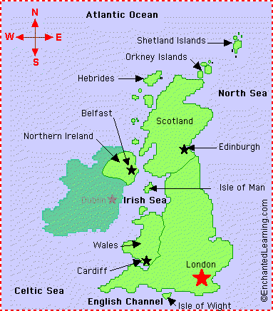 Location: The United Kingdom (UK) of Great Britain and Northern Ireland is a country in Western Europe. It consists of England, Scotland, Wales, and Northern Ireland.
Related Pages:
 British Isles Printout: Label Me! Printout Label the British Isles. Answers |
 Flag of the United Kingdom A page on the flag plus a quiz and coloring printout. |
 UK: Outline Map Printout An outline map of UK to print. Or go to printable worksheets that require research (using an atlas or other geography reference): a simple map research activity, a medium-level map research activity, or an advanced map research activity. |
 UK: Zoom School Learn about the geography, of the United Kingdom of Britain and Northern Ireland. |
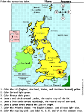 United Kingdom of Great Britain and Northern Ireland: Follow the Instructions Color the United Kingdom of Great Britain and Northern Ireland according to simple directions, such as, "Draw a red circle around Edinburgh, the capital city of Scotland." Or go to the answers. |
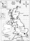 UK: Map Quiz Printout Take a quiz on the map of the United Kingdom of Great Britain and Northern Ireland. Or go to the answers. |
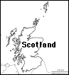 Scotland: Outline Map Printout An outline map of Scotland to print. |
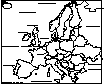 Europe: Label Me! Printout Label the countries and bodies of water of Europe. Answers |
Enchanted Learning®
Over 35,000 Web Pages
Sample Pages for Prospective Subscribers, or click below
|
Overview of Site What's New Enchanted Learning Home Monthly Activity Calendar Books to Print Site Index K-3 Crafts K-3 Themes Little Explorers Picture dictionary PreK/K Activities Rebus Rhymes Stories Writing Cloze Activities Essay Topics Newspaper Writing Activities Parts of Speech Fiction The Test of Time
|
Biology Animal Printouts Biology Label Printouts Biomes Birds Butterflies Dinosaurs Food Chain Human Anatomy Mammals Plants Rainforests Sharks Whales Physical Sciences: K-12 Astronomy The Earth Geology Hurricanes Landforms Oceans Tsunami Volcano |
Languages Dutch French German Italian Japanese (Romaji) Portuguese Spanish Swedish Geography/History Explorers Flags Geography Inventors US History Other Topics Art and Artists Calendars College Finder Crafts Graphic Organizers Label Me! Printouts Math Music Word Wheels |
Click to read our Privacy Policy
| Search the Enchanted Learning website for: |